
What are UTM coordinates (Universal Transverse Mercator)?
UTM coordinates describe a position on a meter-based map grid. The name stands for Universal Transverse Mercator. Each position needs a zone and hemisphere, an easting, a northing and a datum. Without those details, the numbers can refer to different places.
GPS is the satellite positioning system your receiver uses. Latitude/longitude and UTM are ways to display its result. Changing the display does not move you or improve the satellite fix. Choose the format that your map or the person receiving your location can use.
A grid is convenient when you need to plot a point on a paper topo map. Angular coordinates are common in phone map searches and shared location messages.
How to read GPS coordinates: latitude and longitude
In a latitude/longitude pair, latitude tells you how far north or south of the equator the point lies. Longitude tells you how far east or west of the Greenwich meridian it lies. Latitude runs from −90° to +90°; longitude runs from −180° to +180°.
North and east are positive. South and west are negative. Thus 40.50000, -105.25000 means latitude 40.5° north, longitude 105.25° west. We use this fictional pair throughout the angular examples.
For Google Maps, enter latitude first. Other software can ask for longitude first, so check field labels before pasting. Memory aid: latitude lines are rungs on a ladder; you climb them north or south. Longitude lines run from pole to pole; their values measure east–west position.
Keep the sign or the hemisphere. Use either −105.25° or 105.25° W for west longitude, as the receiving format requires. If the input has a separate E/W selector, check its sign requirements before entering the number.
Read the terrain around the resulting pin. A point outside your expected state is an obvious warning; a point on the wrong side of a valley can be harder to spot. Our topographic map guide explains how to compare a position with contours and landmarks.
Decimal degrees, decimal minutes and degrees minutes seconds
The three common angular formats can describe exactly the same point. In each format, the decimal part is a fraction of a different unit. Read the unit symbols before reading the digits.
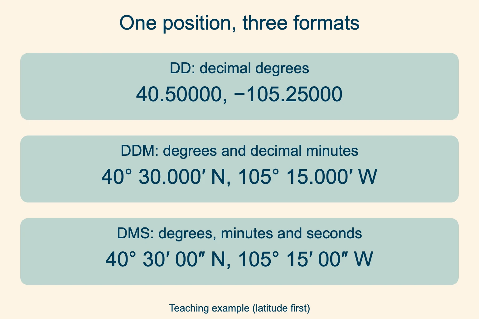
Decimal degrees (DD) 40.50000, −105.25000. The fraction is part of a degree.
Degrees and decimal minutes (DDM) 40° 30.000′ N, 105° 15.000′ W. Some menus call this DMM.
Degrees, minutes and seconds (DMS) 40° 30′ 00″ N, 105° 15′ 00″ W. Seconds can also have a decimal part.
There are 60 minutes in a degree and 60 seconds in a minute. To convert DMS to decimal degrees, add degrees + minutes ÷ 60 + seconds ÷ 3,600, then apply the hemisphere sign to the whole result. For the west longitude above: −(105 + 15 ÷ 60 + 0 ÷ 3,600) = −105.25°.
Going the other way, take the fractional degrees and multiply by 60 to get minutes. For 40.5125°, that gives 40° 30.75′. Multiply the remaining 0.75 minute by 60 to get 45 seconds: 40° 30′ 45″. Keep N or S with that latitude.
Do not read 40° 30.750′ as 40.30750°. Moving the decimal point does not convert the units. In DMS or DDM, the minutes and seconds fields must each stay below 60; carry a rounded 60 into the next larger unit.
Read the easting and northing in a full grid reference
Consider this complete teaching reference: WGS84 · zone 13 · Northern Hemisphere · 500300 m E · 4480650 m N. It is a separate example from the angular pair above. Read the easting first, then the northing.
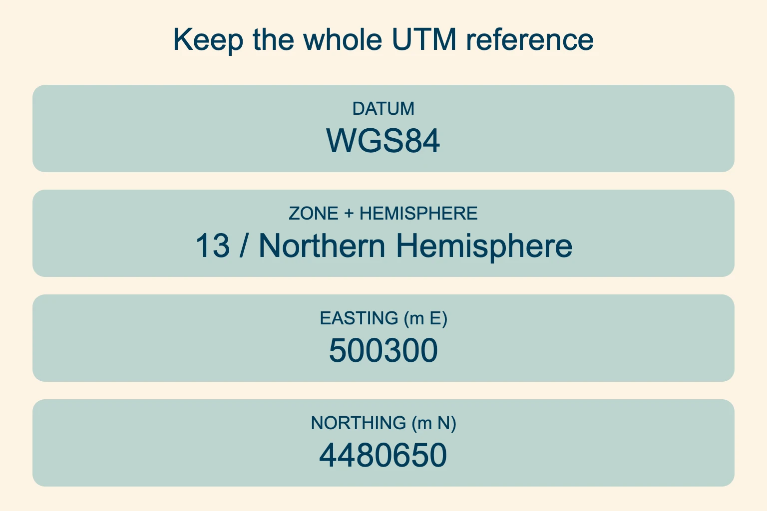
Easting: across the grid 500300 m E is the horizontal value. It increases toward grid east.
Northing: up the grid 4480650 m N is the vertical value. Within the same hemisphere and zone, larger values lie farther grid north.
Reference frame Zone 13, Northern Hemisphere and WGS84 make the two distances interpretable.
The central meridian of a zone has an assigned easting of 500,000 m. That makes the example 300 grid meters east of that meridian. Easting is not a distance from the zone’s western edge. The USGS grid-reading explanation describes this offset and the full numeric labels.
In the Northern Hemisphere, northing starts at zero at the equator and increases northward. In the standard Southern Hemisphere convention, the equator is assigned 10,000,000 m and northing decreases as you travel south. The USGS explanation of southern false northing describes that convention. Southern grid values normally remain positive. Do not add a minus sign to a southern northing as if it were latitude.
The E and N after the numeric values label the axes: easting and northing. That N alone does not tell you which hemisphere the point is in. Write the hemisphere separately when sharing the reference.
Find the UTM zone and distinguish hemisphere from band
A UTM zone is one of 60 numbered longitude strips, generally 6° wide. The numbers increase eastward from the 180° meridian. Norway and Svalbard have exceptions to the usual widths. Use the map collar or a correctly configured map application to find the zone for your point.
A state or country can span several strips. “The zone for California” is therefore not enough information for every trail in that state. Near a boundary, use the zone stated by your map or data source and keep it consistent through the conversion.
Some displays add a latitude-band letter to the zone number. In that notation, 13T means zone 13, band T. A band is not a hemisphere code: band S lies north of the equator. In other software, 13S can mean zone 13 in the Southern Hemisphere. Ask what the letter means when the convention is unclear.
Write North or South in full. For a message or handwritten note, spell out the hemisphere and keep any latitude-band label separately. A bare S is easy to misinterpret.
UTM covers latitudes from 80° south to 84° north. Polar mapping uses other systems, including UPS.
How to read UTM coordinates on a map
First check that the paper map has a UTM grid, and read its zone and horizontal datum. Confirm the grid interval from the labels. On a 1,000 m grid, adjacent full labels differ by 1,000; a different grid spacing needs a different calculation.
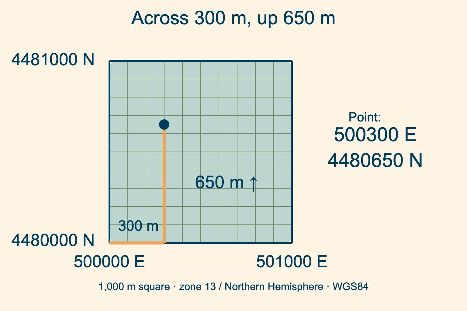
Start at the southwest corner. The west grid line is 500000 E; the south grid line is 4480000 N.
Go across, then up. Move 300 m east and 650 m north within that square.
Keep the full values. The plotted point is 500300 E, 4480650 N.
To read an unknown point, find the grid line immediately west of it. Add the measured eastward offset to that line’s full easting. Then find the line immediately south and add the northward offset to its full northing. A coordinate ruler must match the map scale.
On a 1:24,000 map, 1 cm represents 240 m on the ground. A 1,000 m square is about 4.17 cm wide. The scale calculation describes the printed size; map accuracy is a separate question. If you resize a printed map, its original ruler scale may no longer work; check the printed scale bar.
Map margins sometimes emphasize only the thousands digits. Restore the small-print leading digits from the full labels before entering a position into a GPS. An abbreviated local grid reading can be useful within a group, but it is not a complete location to send to someone elsewhere.
Convert UTM to lat long without losing the reference
An angular-format conversion uses the 60-based arithmetic above. A UTM-to-latitude/longitude conversion also needs a map projection. Dividing a meter value by 60 will not do it.
Record the source reference. Keep the full easting and northing, numbered zone, explicit hemisphere and datum.
Set the source and destination. Use a conversion tool that accepts the complete source coordinate reference system. Choose the destination datum and angular format deliberately.
Check the converted point. Plot the result in a second map view. Confirm the expected area and nearby terrain before using it in the field.
The PROJ documentation gives a northern example using its default GRS80 ellipsoid. Longitude 12°, latitude 56°, in zone 32 produces an easting of 687071.44 m and a northing of 6210141.33 m. Its separate southern example uses an explicit south setting. Keep those settings with the numbers when checking the example.
For US mapping in NAD27 or a supported NAD83 realization, NOAA’s NCAT converter accepts UTM and geodetic coordinates. Its listed input datums do not include WGS84; do not relabel a WGS84 position as NAD83 to make it fit. A coordinate converter can also transform datums, but only when you select the appropriate source and destination. Changing a label from NAD27 to WGS84 leaves the old numbers in place. That is not a transformation.
Find a position in Google Maps, Google Earth or your GPS
Google Maps: latitude first
On a computer, right-click a location in Google Maps. The pair at the top of the menu is latitude and longitude in decimal degrees; click it to copy. To search, paste an angular coordinate pair into the search box. Use a decimal point inside each number and a comma between the two values.
Google’s search instructions list DD, DDM and DMS input formats. Convert a UTM reference to latitude/longitude before using that search workflow. A dropped pin is the point you selected; it is not necessarily your current GPS position.
Google Earth: show a UTM display
In desktop Google Earth, open Tools → Options on Windows, or Google Earth → Preferences on Mac. Under 3D View, change Show Lat/Long to Universal Transverse Mercator. Google’s coordinate display guide covers those settings. Check whether the readout follows the cursor or the center of the map.
Phone and handheld receiver settings
On an iPhone or Android phone, use an app’s current-location or coordinate view, then read its format and reference settings. Garmin menu names vary by device; look up Position Format and Map Datum in the manual for your model. Do this at home with a known point before relying on it at a trail junction.
Save the maps you need for offline use and check that they open without a connection. GPS reception and downloading map data are separate functions. A working coordinate readout does not mean the background map has been saved.
Match the datum: WGS84, NAD83 and older maps
A datum defines the reference frame behind the numbers. WGS84 is common in GPS devices. USGS maps can use NAD83 or, on older sheets, NAD27. Read the actual map notes instead of assuming.
The USGS explanation of map datums warns that coordinates in different datums can differ by hundreds of meters. Match your receiver’s output to the paper map’s stated reference, or use a proper transformation. Keep the original reference in your notes so someone can check the conversion later.
WGS84 does not mean “latitude and longitude.” It is a reference frame that can underlie angular or projected coordinates. UTM is the projection/grid system. Those terms answer different questions about the same location.
Coordinate precision is different from GPS accuracy
Precision describes how finely a value is written. Accuracy describes how close the measured position is to your actual location. A long coordinate string can precisely describe an inaccurate fix.
Writing a UTM value to the nearest meter records meter-level precision. It does not prove the receiver located you within a meter. GPS.gov explains that receiver performance depends on signal blockage, satellite geometry and local conditions. Trees and steep terrain can interfere with reception.
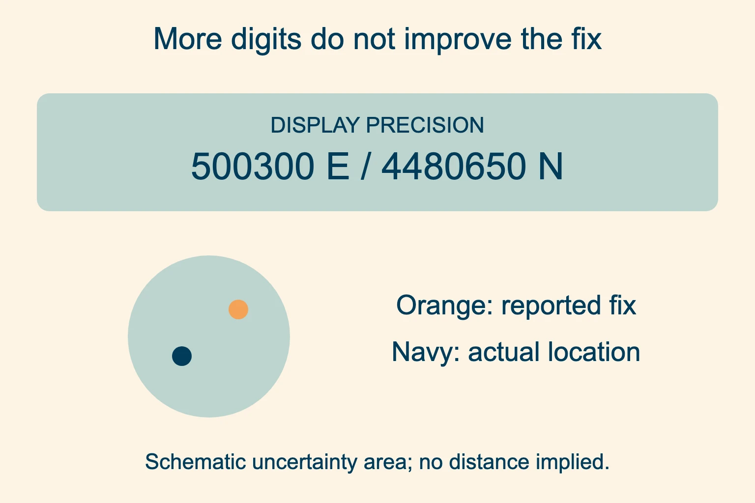
Recorded precision The coordinate string can show whole meters even when the fix is less accurate.
Actual uncertainty Check the receiver’s estimate and compare the point with nearby terrain.
Keep the digits the device gives you when sharing a position. Also report the displayed accuracy estimate if available, especially when the point is near a cliff, river or junction. Treat a point near a hazard as approximate.
Read coordinates aloud and share them in an emergency
Say the format first. For the angular teaching example, you could say: “Decimal degrees. Latitude four zero point five zero zero zero zero north. Longitude one zero five point two five zero zero zero west.” Do not omit west or replace “point” with a pause.
For a grid position, say the datum, zone and hemisphere before the full easting and northing, reading the digits separately. Ask the listener to read the reference back, including the format. Follow the dispatcher’s or service’s own procedure if it differs.
In a US emergency, call 911 if you can. Give your location, the trail or area where you started, visible landmarks and the nature of the emergency. The NPS Outdoor Emergency Plan includes GPS coordinates among the information to provide. Follow the dispatcher’s instructions; do not delay a call while trying to convert formats.
Check that you are reading a current fix. An old waypoint or manually placed pin can show somewhere else. Say if the position is uncertain or last known. If you are waiting for rescue, stay put unless there is an immediate threat to your life, as the NPS plan advises.
UTM vs latitude and longitude: common questions
Is UTM better than latitude and longitude?
Neither is better overall. A meter grid suits plotting on a matching topo map; degrees suit map searches and shared pins.
What is the difference between UTM and MGRS?
MGRS builds on the UTM grid in its coverage area, adding a latitude-band designation and two letters for a 100 km square, followed by equal-length easting and northing digit groups. Do not paste a shortened MGRS string into fields expecting full UTM meter values.
Can latitude exceed 90 degrees?
No. Valid latitude is between 90° south and 90° north. If an angular latitude field exceeds that range, check for swapped latitude/longitude or a meter-based grid value copied into a degree field.
How do I know which UTM zone I am in?
Read the zone in the map collar or your app’s coordinate reference settings for the selected point. Do not rely on a country-wide guess. Check the selected point rather than the map view’s center.
Why does my coordinate put the pin in the wrong place?
Check the sign or hemisphere, latitude/longitude order and DD/DDM/DMS format first. For a projected grid, also check the zone, datum and full leading digits. Then assess whether the point is a live fix, a saved waypoint or a manually placed pin.
Practice with your map. Plot a known point before you need the skill on a trail.